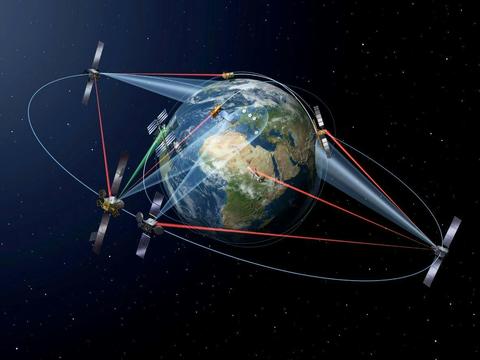
Pioneering the laser communication revolution
SpaceDataHighway™ (SDH) is a public–private partnership between ESA (European Space Agency) and Airbus that provides highbandwidth capability for both LEO satellites and airborne platforms via
laser communication infrastructure.
Utilising the Airbus owned and operated European Data Relay System (EDRS), SpaceDataHighway enables the transfer of data(including imagery, voice and video) from your LEO satellites and airborne platforms, by laser communications via the EDRS-A andEDRS-C geostationary satellites, to receiving ground stations in Europe.
SpaceDataHighway illustrates the magnitude of change in the speed of space communications and uses cutting-edge laser technologyand satellites in geostationary Earth orbit to deliver unique and secure data transfer services in real time.
High-volume data transfer via ultra-broadband laser communication
SpaceDataHighway enables high-volume data, time-critical and sensitive information to be transfered outside the vicinity of groundnetworks, in turn supporting faster and longer access to air and space assets, securely transferring information in hostile electronicwarfare environments, ensuring stealth communications and allowing transferring large volumes of data generated by powerful sensorsor to enable the combat cloud concept.
With the ability to be used across; military communications, intelligence, surveillance and reconnaissance (ISR), open oceansurveillance, environmental and climate change monitoring, and emergency response, SpaceDataHighway improves data latency atglobal scales, enhanced reactivity and routing of data over secure and trusted infrastructure.
What can SpaceDataHighway do ?
- High-volume data transfer from Earth observation satellites, airborne platforms and other users at a data rate of 1.8 Gbps, with transmit volumes of up to 40 terabytes per day.
- Mature, space-proven technology with high bandwidth spectrum availability, low probability of intercept/detection and resistanceto jamming.
- Ensures high volume data transfers beyond line-of-sight (BLOS).
SpaceDataHighway: a public-private partnership
The European Commission's* Earth observation programme is made up of the four Sentinel-1 and Sentinel-2 satellites of Copernicus, all of which are equipped with laser communication terminals that will significantly accelerate the delivery of large volumes of time-critical data to Earth monitoring centres within Europe.
The first SpaceDataHighway relay, comprising a laser communication terminal and a Ka-band inter-satellite link, was launched in 2016as a secondary payload aboard a commercial telecommunications spacecraft, offering coverage from above the American East Coast to India. SpaceDataHighway laser connectivity is controlled 24/7 by the Mission Operation Centre at Airbus premises near Munich, Germany, where operators programme the space and ground segment, and monitor the performance of communication based on transmission requests from customers.
As of 2019, SpaceDataHighway reached the milestone of 25,000 successful laser connections during its first three years of routine operations. With reliability rate of 99.4%, these connections downloaded more than 1500 terabytes of data.
On the 10 July 2019, the EDRS team successfully demonstrated the EDRS timeliness capability, at the European External Action Service in Brussels. This highlighted to the stakeholders from the EO user community the concrete advantages of using SpaceDataHighway to meet their real-time requirements. A duplex event in Tokyo was held in cooperation with the Delegation of the European Union to Japan.
The second satellite, EDRS-C was launched on the 06 August 2019 and it extends the coverage, capacity and redundancy of the system.
*The initial EDRS laser terminals were developed and built by TESAT-Spacecom, an Airbus subsidiary, and funded by the DLR German Aerospace Centre. The European Commission was the first customer of the SpaceDataHighway.


